
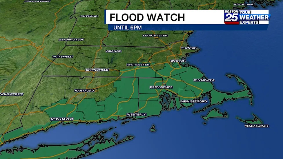
Residents across southern New England, particularly within Massachusetts, have been placed on high alert as atmospheric conditions bring the threat of heavy downpours and dangerous localized flash flooding to the region. Regional forecasters and emergency personnel are monitoring a fast-developing storm system capable of generating excessive water accumulation across several critical transportation corridors and residential communities.
The National Weather Service has enacted an official flood watch covering a wide swath of Massachusetts territory. The advisory spans eight distinct counties across the state, encompassing Bristol, Plymouth, Barnstable, Dukes, Nantucket, Worcester, Norfolk, and Suffolk counties. This broad geographic range includes major population centers, coastal communities, and island jurisdictions that could face severe hydrological impacts as the system moves through.
According to official weather statements, this widespread flood watch is designated to remain in effect through 6:00 p.m. on Sunday. Emergency planners emphasize that this extended multi-hour timeframe represents the primary window of concern, during which persistent moisture and slow-moving storm cells could overwhelm municipal drainage systems and local waterways before tapering off in the evening.
Providing detail on the storm's trajectory, Boston 25 meteorologist A.J. Mastrangelo noted that a substantial cluster of heavy rain is moving across the Commonwealth. Mastrangelo explained that this band of concentrated precipitation would slide into Southeast Massachusetts through the late morning hours, keeping active flood watches in place along and south of the Massachusetts Turnpike throughout the bulk of the day.
The meteorological setup features an expansive coverage of rain showers accompanied by embedded thunderstorms. Forecasters warn that these embedded convective cells have the potential to produce localized, narrow bands of torrential rainfall, significantly heightening the risk of sudden water buildup in affected neighborhoods.
Across the broader advisory zone, general precipitation totals are anticipated to be substantial, with widespread rainfall amounts projected to range between 0.50 inches and 2 inches. While these baseline accumulation figures alone represent a significant soaking for the region, the primary danger stems from the localized spikes embedded within the storm system.
Forecasters have issued particular warnings regarding the development of narrow, highly localized corridors of extreme downpours. In areas where these intense bands stall or set up, rainfall amounts could rapidly reach between 2 and 4 inches within a compressed three-hour timeframe, creating conditions highly conducive to rapid runoff and flash flooding.
The National Weather Service in Boston highlighted the forecasting challenges associated with these pinpointed downpour bands, noting that precise locations remain difficult to project ahead of time. Forecasters stated that while uncertainty persists regarding exactly where these heavy bands will form, the potential for localized flash flooding remains a serious concern for any community positioned directly beneath them.
Meteorologists are especially concerned about the implications for densely developed environments. The National Weather Service cautioned that localized flash flooding is a distinct risk, particularly if these heavy rain bands track over vulnerable urban centers where extensive pavement, impervious surfaces, and complex stormwater infrastructure can quickly become overwhelmed.
With hazardous weather threatening travel and property, the Boston 25 Weather Team has placed the region under a severe weather alert. Forecasters are urging motorists, property owners, and local residents across the impacted counties to track real-time meteorological updates on social media and broadcast platforms as the storm progresses.
Beyond rainfall and road hazards, state agencies are preparing for potential disruptions to electrical infrastructure. The Massachusetts Emergency Management Agency is advising residents to utilize its real-time power outage viewer to monitor community-level, regional, and statewide outage counts, as well as to access restoration estimates provided directly by local utility companies.
State emergency management officials also recommend that the public take advantage of live weather radar systems and interactive forecasting tools available through Massachusetts Emergency Management Agency digital platforms. These mapping resources allow residents to track the movement of rain bands across their specific neighborhoods in real time.
For residents requiring non-emergency assistance, social services, or emergency information during the weather event, community hotlines such as Mass211 remain accessible. Broader emergency support and guidance are also backed by resources available through the Federal Emergency Management Agency.
Monitoring of the regional weather disturbance is being coordinated across multiple forecast jurisdictions, including National Weather Service offices in both Boston and Albany, New York. These agencies will continue evaluating radar data and surface observations throughout the afternoon, updating alerts as rain clusters traverse southern New England.






(0)