
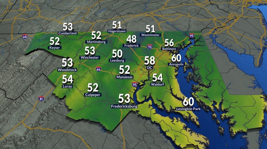
Residents across the greater Washington, D.C., metropolitan area are experiencing a distinct shift in the seasonal atmosphere this Tuesday morning, as an invigorating burst of cooler air delivers an unmistakable preview of the impending autumn season. Thermometers across the region registered starting temperatures in the 50s, creating a noticeably cool and refreshing environment for the early morning commute.
The sudden dip in morning readings has prompted local commuters, students, and early-morning exercisers to reach into their closets for light jackets and extra layers before stepping outside. For many throughout the capital area, this marks the first time in several months that outer layers have been a practical necessity during early morning travel routines.
Meteorological data highlights the significance of this morning's refreshing chill, noting that the District had not experienced morning lows dropping into the 50s since June 3rd. That prolonged gap underscores the persistent warmth that dominated the summer months, making the arrival of this crisp, fall-like air mass particularly striking for local residents.
Despite the brisk start to the day, the early morning chill is expected to be short-lived as strong daytime heating takes hold. Forecasters indicate that temperatures will stage a rapid and comfortable rebound throughout the afternoon hours, with peak readings climbing into the upper 70s and lower 80s across the region.
The afternoon warming will be accompanied by an abundance of bright sunshine and remarkably low humidity levels. These pleasant atmospheric conditions create an ideal environment for outdoor dining, recreation, and afternoon travel, standing in stark contrast to the muggy conditions typical of mid-summer in the mid-Atlantic.
The tranquil and comfortable weather pattern is projected to carry over into Wednesday, which will offer another brisk start to the day. While Wednesday morning will still feature a crisp and cool feel, forecasters note that low temperatures will not be quite as chilly as those recorded during Tuesday morning’s commute.
As Wednesday progresses, a modest warming trend will begin to establish itself across the area. Afternoon highs are anticipated to reach the lower to mid-80s under mostly sunny skies, providing another pleasant and manageable day for outdoor activities, albeit with slightly higher thermometer readings than the day before.
Weather experts advise residents to take full advantage of the exceptionally pleasant conditions spanning both Tuesday and Wednesday. The relatively dry air and mild afternoons represent a brief meteorological window before more humid and unsettled conditions begin working their way back into the forecast toward the latter half of the week.
By Thursday, the regional weather pattern will undergo a noticeable transformation as moisture levels begin to rebound. The resurgence of higher humidity, combined with daytime highs climbing into the upper 80s beneath partly sunny skies, will bring back a distinctly summer-like atmosphere to the region.
The shift toward more active weather will culminate on Friday as a cold front advances toward the mid-Atlantic from the northwest. Ahead of this approaching boundary, Friday will maintain elevated humidity levels and high temperatures once again peaking in the upper 80s, setting up an unstable environment across the region.
As the frontal boundary pushes closer during Friday afternoon and evening, it is expected to trigger the development of isolated showers and thunderstorms. Commuters and those with outdoor Friday evening plans are encouraged to stay mindful of changing sky conditions and potential localized downpours as the front crosses the area.
In the wake of the frontal passage, the upcoming weekend will experience a slight moderation in daytime temperatures. Highs on both Saturday and Sunday are forecast to settle back into the mid-80s, offering typical late-summer temperatures across the metropolitan corridor.
While both weekend days will feature similar high temperatures, Sunday is currently favored to bring the higher likelihood of rain. Forecasters highlight a greater potential for scattered showers and thunderstorms on Sunday compared to Saturday, which may influence weekend outdoor planning across the District, Maryland, and Virginia.
Looking further ahead into the beginning of the next workweek, daytime conditions are slated to moderate even further. High temperatures on Monday are expected to level off around 80 degrees under predominantly cloudy skies, providing a mild and overcast backdrop for regional commuters.
This gradual temperature slide will lead directly into next Tuesday, which marks the official astronomical beginning of the fall season. As the calendar turns toward the equinox, the broader weather pattern appears poised to align with the changing season, following the brief taste of autumn that kicked off the current week.







(0)